Feb 24, 2024
Interactive Map App
Interactive mapping project for tracking customer locations.
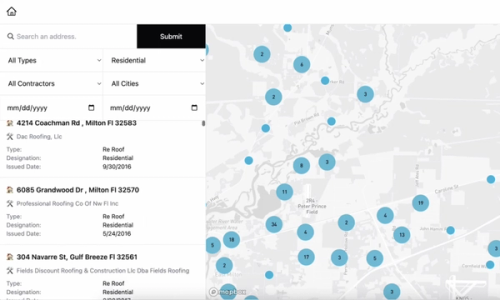
In a recent project, I leveraged Mapbox to create a dynamic, interactive map for a client. This application allows users to upload CSV files containing location data, which then visually appear on the map. Built with Remix and styled with Tailwind CSS, the platform is designed for ease of use and visual appeal.
The interactive map not only displays locations but also offers users the ability to explore, select from a list for focused views, and apply filters to refine their search. This functionality enhances the user experience by making data exploration intuitive and engaging.
To support the data management and scalability needs of this application, I integrated Prisma ORM, Planetscale, and My SQL. This backend setup ensures efficient handling of location data and user interactions.
Additionally, the application includes a feature for visualizing data through charts. This aspect adds a valuable layer to the platform, enabling users to see patterns and insights related to the location data in a more digestible format.
This project highlights the power of combining modern web technologies with interactive mapping tools like Mapbox to create rich, user-centered applications. It stands as a testament to how digital solutions can transform data into interactive and informative experiences.
This project can be shared upon request.


